Deploy
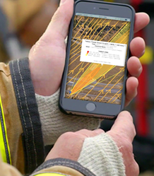
Imagine receiving an emergency call and being on your way to a situation you know little more of than the location. Needing to arrive on site, fully assess the situation, set up an incident command station, and gather multiple current and forecasted data takes precious time.
LR-x® allows for easy deployment while in route to an incident. Deployed in less than 60 seconds with simple selection of an incident location, the all mobile LR-x® application will change the way you gain situational awareness allowing you to spend less time calculating and inputting information, and more time tending to the situation in front of you.
LR-x® allows for easy deployment while in route to an incident. Deployed in less than 60 seconds with simple selection of an incident location, the all mobile LR-x® application will change the way you gain situational awareness allowing you to spend less time calculating and inputting information, and more time tending to the situation in front of you.
|
Sensor Module
Sensor modules used for LR-x® vary depending on which model is used. Pulling weather from public weather sensors while in route assists in keeping you and your team safe by providing initial generation of 3D Wind Field and Plume Models prior to arrival. A secondary option is to set up incident command once on site. Once situated, tip up your Coastal WEATHERPAK to immediately be synced with the LR-x® system. Current as well as forecasted weather conditions are used for our 3D Wind Field and ALOHA models. Using both Current and Forecasted weather data from NOAA vastly improves situational awareness and decision support. LR-x® is offered as a both a mobile/fixed application, or standalone/cloud. The fixed system is ideal for Refineries, High Value Targets, Sports Stadiums, while mobile versions are ideal for Military, rail, or quick response situations. |
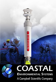
The Coastal Environmental Systems WEATHERPAK is a unique
self-contained one-piece design that makes it the most easy-to-use
and versatile portable weather station available. These atmospheric
sensors allow for seamless feed into the LR-x model module.
|
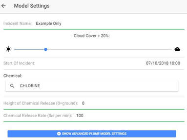
The capability to perform what-if-scenario for training and preparation has never been easier, and the possibilities are endless. With both minimum Model Setting requirements and an Advance Model Settings option, scenarios can be ran using specific parameters including but not limited to Incident Name, date and time, location, and source.
All live and training incidents are archived in Model History for after action reporting allowing for time-saving post incident analysis. These incidents are easily retrieved within the LR-x® application when searching by Incident Name or date. |